What is a metropolitan statistical area?
Published: Sep 12, 2024
Metro New Orleans was established in 1950 and the parishes that make up Metro New Orleans have changed over time. What determinations are used to define a metro area come directly from the federal government’s Office of Management and Budget. Metro areas are analyzed yearly by the Census Bureau and if a parish no longer meets the criteria determining it to be part of a metro area, it is removed, and vice versa. This brief aims to make clear how a metro area is defined and why the parishes (or counties) that make up a metro may change over time.
In the United States, most of the nation’s population and economic activity is located within metropolitan areas. The top 50 metro economies account for 64 percent of the entire national economy (GDP), as of 2022.1 Metropolitan regions are among the most consequential ways that human settlement and economic activity are organized geographically. However, unlike a state, parish, or municipality, metropolitan regions have no clear, objective boundary. Heading east on I-10 from New Orleans, once you see the welcome sign and pass the rest stop, you know you’ve left Louisiana and entered Mississippi. But heading west, at what point do you leave the New Orleans region or enter the Baton Rouge region? To which region, if either, do the River Parishes belong? The answers depend on context, but standardized statistical definitions can be helpful, especially when it comes to reporting and analyzing data.
The Census Bureau, and other federal agencies, publish data at various geographic levels, ranging from individual blocks to the entire United States. For the last 70 years, the Office of Management and Budget (OMB) has maintained a set of consistent statistical definitions for metropolitan regions of the United States to enhance the value of data provided by federal statistical agencies. The current rules are published in the Federal Register and are used to consistently define metro areas across the country (Management and Budget 2021).
To make the abstract idea of a metropolitan region more concrete, objective, and consistent with data reporting standards, the OMB uses a few key concepts:
A Core Based Statistical Area: As defined by the OMB, a core-based statistical area (CBSA) is an “area containing a large population nucleus—or urban area—and adjacent communities that have a high degree of integration with that nucleus.” There are two types of CBSAs, metropolitan statistical areas and micropolitan statistical areas, both defined as groups of counties (or parishes in Louisiana). Micropolitan statistical areas (µSAs) are generally anchored by smaller cities and towns in areas that are otherwise rural in character or remote from larger urbanized regions. For example, Washington Parish is the Bogalusa, LA micropolitan statistical area. Metropolitan statistical areas (MSAs) range from small- and mid-sized urban regions to the largest urban agglomerations in the country, like the New York, Los Angeles, and Chicago MSAs. Louisiana has 10 metropolitan statistical areas, and the largest are the New Orleans-Metairie and Baton Rouge MSAs. When The Data Center and other groups that analyze and publish data use terms like “metros,” “metropolitan areas,” or “regional economies,” we are usually referring to these official delineations of counties and parishes into MSAs.2
In most cases, MSAs encompass a core city, like New Orleans, and the smaller municipalities and suburban areas that surround it. Because MSAs are defined by county boundaries, they may also have portions that are rural in character. For example, large parts of every metro parish, even some areas that are within the city limits of New Orleans, are quite rural in character and density.3 What makes these areas part of the same MSA is that they lie in parishes with strong economic and social linkages to an urbanized core, like the parts of Orleans and Jefferson parishes where much of the metro area’s residents live and/or work. As we explain below, this is why data on daily commuting for work plays a key function in defining CBSA boundaries.
Making comparisons with MSAs
MSAs are often used for comparing the sizes and characteristics of different regions of the country, and they play an important role in comparing local economic and demographic conditions. MSAs often give better apples-to-apples comparisons than municipal or county boundaries because MSAs are defined by functional integration within an urbanized region whereas political boundaries are, well, political. They vary for a mix of idiosyncratic and historical reasons, like the timing of settlements and subsequent waves of urban growth, the prevailing methods of land subdivision imposed by non-indigenous settlers, state and local factors shaping municipal annexation, and natural barriers like mountains and bodies of water. Generally speaking, cities and counties tend to be smaller in the eastern United States than in the west. The most populous MSA, New York-Newark-Jersey City, has 22 counties; the second most populous, Los Angeles-Long Beach-Anaheim, has only two. New York City alone is comprised of five counties, one for each borough, but Los Angeles County encompasses the entire City of Los Angeles, 87 other municipalities, and unincorporated areas. Similar discrepancies exist when comparing individual cities. The municipal population of Phoenix is triple that of Atlanta or Miami, but Atlanta and Miami are the core cities of metropolitan areas with larger economies and populations than Phoenix. To make consistent comparisons between New York and Los Angeles, between Phoenix and Miami, or between any other metropolitan regions, analysts often use the federal MSA definitions.
The Urban Area: The OMB uses another geographic concept to define CBSAs, the “Urban Area”. This is a contiguous, densely settled area that is not defined in terms of any political subdivisions. When St. Tammany was added in 1963, the New Orleans-Metairie MSA actually had three urban areas:
- One large urban corridor stretching along both sides of the Mississippi River from western St. Bernard and northern Plaquemines, through the core of Orleans and Jefferson, and into St. Charles and St. John the Baptist Parishes;
- One smaller urban area in west St. Tammany, covering the areas around Mandeville and Covington; and
- One smaller urban area in east St. Tammany, covering the areas around Slidell.
Note that only Lake Pontchartrain separates the two north shore urban areas in St. Tammany from the larger south shore urban area. Indeed, both north shore urban areas are largely clustered around the shortest road connections to Orleans and Jefferson Parishes: the I-10 Twin Span bridge and the Causeway bridge. This pattern reflects the importance of access to the south shore to development on the north shore.
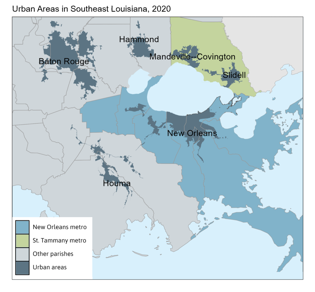
Because they share a contiguous urban area that contains most of the region’s population, Orleans, Jefferson, Plaquemines, St. Bernard, St. Charles, and St. John the Baptist are classified as “central counties.” Prior to the 2020 update, St. Tammany had been classified as an “outlying county” because its residents commuted in sufficient numbers to work in the “central counties,” which includes the regional economy’s main employment districts in Orleans and Jefferson parishes.
Worker Commuting Patterns: The final ingredient in the OMB’s recipe for defining metropolitan and micropolitan areas (or CBSAs) is data on the commuting patterns of workers. If at least 25 percent of the workers who live in a county commute to work in the central counties of a CBSA, or if at least 25 percent of the workers who work in a county commute from their homes in the central counties, that county qualifies as an outlying county in the CBSA. A central county is associated with the Urban Area that accounts for the largest portion of the county’s population. The central counties associated with a particular Urban Area are grouped to form a single cluster of central counties for purposes of measuring commuting to and from potentially qualifying outlying counties.
The federal government maintains these definitions for statistical purposes and does not take into account any private or political considerations other than specific data sources on population and commuting. In other words, CBSA definitions are meant to provide an objective “data-driven” standard that applies to the entire United States. This consistency is important because some areas may wish to negotiate the definitions to appear larger or more independent than the official statistical definition implies. In order to manage the diversity of political boundaries in the U.S., a common method must apply everywhere. In the U.S., there are 392 metropolitan areas and 547 micropolitan areas (Management and Budget 2023), which are re-evaluated after each decennial census.
The definition of the New Orleans-Metairie MSA has changed over time. This is due partly to changes in the OMB’s method and data sources and partly to the fact that metro areas grow and change over time. Here is a short history of how Metro New Orleans’ official statistical definition has evolved:
- 1950: Metro New Orleans’ area is first delineated to include three parishes – Orleans, Jefferson, and St. Bernard.
- 1963: St. Tammany is added (the Causeway Bridge first opened in 1956, reducing commute times and fueling population growth on the north shore).
- 1983: St. Charles and St. John the Baptist are added (the stretch of I-10 between La Place and Kenner opened in 1971).
- 1993: Plaquemines and St. James are added.
- 2003: St. James is removed.
- 2013: St. James is once again added.
- 2023: St. Tammany is removed and designated as its own metropolitan area.
Sources and Footnotes
1Author analysis of data from the Bureau of Economic Analysis.
2There are also Combined Statistical Areas, which contain multiple CBSAs. The classic examples are multi-nucleated regions like Washington DC, the San Francisco Bay Area, and Dallas-Fort Worth; but New Orleans also anchors a consolidated statistical area that includes Hammond and Tangipahoa Parish. St. Tammany is still included in this Combined Statistical Area.
3These areas don’t feel “urban” in the sense that the density of activity and the built environment – physical homes, workplaces, infrastructure, etc. – is much lower than in a city or suburb.